
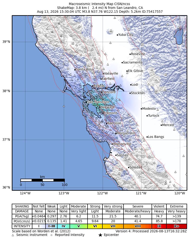
If you felt the San Leandro earthquake but your phone did not warn you, that does not necessarily mean your settings failed. The U.S. Geological Survey reviewed the August 13, 2026 event at magnitude 3.84, below California’s published magnitude threshold for a MyShake public warning. The better response now is to check official updates, expect that smaller earthquakes may continue, and inspect your immediate surroundings for hazards—not to treat every creak as proof that a larger quake is imminent.
USGS located the earthquake about 4 kilometers north of San Leandro at 8:30:04 a.m. PDT, at a depth of roughly 5.2 kilometers. At our 10:06 a.m. PDT check, the event carried a green PAGER impact alert, no tsunami flag, and nearly 7,000 “Did You Feel It?” responses. KSBW reported that shaking was felt as far away as the Santa Cruz Mountains.
Fast answer: California says MyShake warnings are sent for earthquakes measured at magnitude 4.5 or higher when weak-or-greater shaking is expected. Wireless Emergency Alerts use an even higher published threshold: magnitude 5.0 and light-or-greater expected shaking. A reviewed magnitude of 3.84 falls below both thresholds.
What USGS has confirmed
| Detail | Reviewed information | What it means |
|---|---|---|
| Magnitude | 3.84 | The number may have appeared as 4.0 or 4.1 in early reports because automatic estimates are revised as more station data arrives. |
| Time | 8:30:04 a.m. PDT, August 13 | This is the local Bay Area event time. |
| Location | 4 km north of San Leandro | USGS reports an epicentral reference, not a claim that every neighborhood experienced identical shaking. |
| Depth | About 5.2 km | A relatively shallow local earthquake can be readily felt even when its magnitude is modest. |
| USGS impact alert | Green | PAGER uses green for an expectation of little or no broad impact; it is not a guarantee that no individual item fell or no isolated damage occurred. |
| Tsunami flag | 0 / no alert indicated | The USGS event record did not flag a tsunami threat. |
Magnitude and shaking intensity are different measurements. Magnitude is one estimate of the earthquake’s overall size. Intensity describes how strongly it shook at a particular location and can change with distance, soil, geology, and buildings. That is why one person may describe a sharp jolt while someone farther away reports a slow sway—or nothing at all.
Why didn’t MyShake or a government alert appear?
Earthquake early warning is not a notification for every earthquake that can be felt. California’s official alert page says the MyShake app provides warning for earthquakes of magnitude 4.5 or higher when at least Modified Mercalli Intensity III, or weak shaking, is expected. Wireless Emergency Alerts are listed for magnitude 5.0 or higher with at least MMI IV, or light shaking, expected.
This San Leandro event’s reviewed magnitude was below those public thresholds. It may still appear afterward in an earthquake log because displaying a detected event is different from issuing a warning before shaking. People very close to an epicenter can also have little usable warning time: sensors must first detect an earthquake that has already begun, estimate it, and distribute a message before the stronger waves reach the phone’s location.
Checking your settings is still worthwhile for future events. California advises MyShake users to keep location access enabled; Android users can check the Earthquake Alerts setting under Safety and Emergency or Location, depending on the phone. But turning on every setting would not require MyShake to send a warning for a magnitude-3.84 event.
Were there aftershocks?
Yes. In a 30-kilometer USGS catalog search through 10:06 a.m. PDT, three smaller nearby events followed the 8:30 a.m. earthquake:
| Local time | Magnitude | USGS location |
|---|---|---|
| 9:07:18 a.m. PDT | 2.99 | 3 km north-northeast of San Leandro |
| 9:07:22 a.m. PDT | 2.82 | 3 km north of San Leandro |
| 9:38:15 a.m. PDT | 1.66 | 4 km north-northeast of San Leandro |
This table is a time-stamped snapshot, not a promise that the sequence has ended. USGS defines aftershocks as smaller earthquakes in the same general area after a larger event, and their frequency usually decreases with time. If a later event is larger, scientists may reclassify the earlier earthquake as a foreshock. That label can only be assigned afterward.
USGS says the worldwide chance that an earthquake will be followed by a larger nearby earthquake within a week is about 5 percent. That is a broad statistical rule, not a tailored forecast for this particular sequence. USGS generally issues its detailed automated aftershock forecasts for U.S. mainshocks above magnitude 5, so it would be misleading to invent a precise San Leandro probability from the smaller events listed above.
A five-minute safety check after the shaking
- Look for injuries first. Use 911 for life-threatening emergencies rather than for general earthquake information.
- Put on sturdy shoes. Broken glass and fallen objects can be easy to miss, especially near cabinets and windows.
- Check for the smell or sound of leaking gas. If you suspect a gas leak, leave the area and follow utility and fire-department instructions. USGS advises shutting off the main gas valve only when a leak is suspected; a professional may be required to restore service.
- Check electrical and water hazards. Do not touch downed power lines or objects in contact with them. If wiring is visibly damaged, shut off power only if you can do so safely.
- Inspect walls, floors, stairs, doors, and windows. New major cracks, missing supports, jammed exits, or a leaning chimney deserve professional attention. Do not enter a visibly damaged building.
- Open cupboards carefully. Items may have shifted against a door and can fall when it opens.
- Photograph actual damage. Keep a record before cleanup or repair and contact the appropriate property manager, insurer, or local building authority.
If shaking resumes, Drop, Cover, and Hold On. Do not run toward a doorway or glass. Afterward, follow local public-safety instructions and avoid spreading screenshots that no longer match the current USGS event page.
Why did BART slow trains for a quake below the phone-alert threshold?
KSBW reported temporary reduced speeds while BART inspected tracks, followed by residual delays. That response is consistent with BART’s published earthquake plan: trains are held briefly after an earthquake, then operators move at reduced speed while visually inspecting the trackway. BART also says its own system can automatically reduce train speed when calculated shaking reaches its operational threshold.
Those actions answer different questions. A public phone-warning threshold asks whether a broad alert should interrupt people based on estimated magnitude and expected shaking. A transit operator’s threshold asks whether equipment should slow so infrastructure can be checked. BART taking precautions does not mean authorities secretly expected a destructive earthquake, and the lack of a phone warning does not mean the transit inspection was unnecessary.
Should you submit a “Did You Feel It?” report?
Yes, if you experienced the earthquake—even if nothing broke. USGS uses “Did You Feel It?” responses to map how shaking varied from place to place, supplement instruments, and help emergency responders understand the felt area. Describe what happened at your location rather than copying someone else’s account.
Use the current USGS event page for event ID nc75417557. The report count and intensity map will continue changing as more people respond. Your experience can be useful precisely because magnitude alone does not show the intensity at every address.
Be cautious with unexpected texts that use an earthquake to request donations, passwords, payments, or urgent account action. Verify the event through USGS or a local agency first, then use our official source before opening a suspicious link before opening any link.
What this earthquake does not tell us
- It does not provide a date or time for the next large Bay Area earthquake.
- It does not prove that a larger earthquake is about to happen.
- It does not erase the Bay Area’s long-term earthquake risk.
- It does not mean every home requires an emergency repair.
- It does provide a good reason to check alert settings, secure heavy items, review family contacts, and know how to shut off utilities safely.
Earthquakes cannot currently be predicted with a specific time, place, and magnitude. Treat claims that this small sequence “guarantees” an imminent major quake as unsupported unless an official agency issues new information. Preparedness is useful without turning uncertainty into a prediction.
Sources and methodology
- USGS event page for the August 13 San Leandro earthquake
- USGS earthquake catalog service used for the time-stamped nearby-event check
- Earthquake Warning California: public alert thresholds and settings
- USGS: probability of a larger nearby earthquake
- USGS: what to do after an earthquake
- BART: earthquake operating and passenger-safety procedures
- KSBW: initial local report and BART effects
Methodology: We checked KSBW’s local report against the reviewed USGS GeoJSON event record and queried the USGS catalog within 30 kilometers of San Leandro from 8:00 a.m. through 10:06 a.m. PDT on August 13. We separately verified California’s public warning thresholds, USGS aftershock guidance, and BART’s official earthquake procedure. All changing event numbers in this article are explicitly dated and should be rechecked on the USGS page.